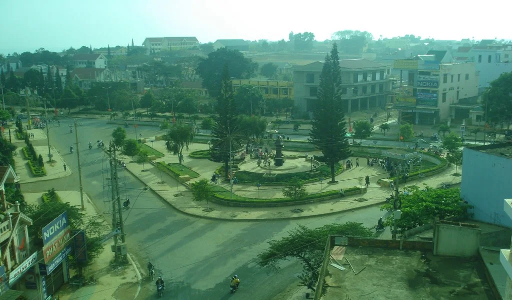

Buôn Hồ
Buôn Hồ was a town for sixteen years and six months. It was made one on 23 December 2008, cut out of the southern half of Krông Búk district, and on 1 July 2025 it stopped being one — not through decline or annexation, but because Vietnam abolished every district-level administrative unit in the country on the same day. An entire tier of government vanished in a single stroke. What remains carries the same name at a smaller scale: a ward of roughly sixty-seven square kilometres and about 62,780 people, where the town had spread across some 282. The buildings did not move. The coffee did not move. Only the box around them changed.
The Basalt Underneath
Everything here rests on old lava. Buôn Hồ sits between 650 and 700 metres on a plateau of gently domed slopes that tilt away to the south and east, and more than ninety per cent of its surface is reddish-brown or yellow-brown soil weathered from basalt — deep, well drained and unusually rich. That single geological fact explains the whole economy. These are the soils that perennial industrial crops want, and the western slopes are given over almost entirely to coffee and rubber. Roughly fifty-five per cent of the land is flat enough to build on, and that portion runs along National Highway 14, which carries the settlements, the workshops, the drying yards and the traffic. Drive out from Buôn Ma Thuột, forty kilometres to the southwest, and the coffee simply does not stop.
Two Seasons and Nothing Between
The highland monsoon here is not a gradation but a switch. From May to October the town takes 1,387 millimetres of rain, ninety-two per cent of its annual total, with August and September each delivering around 255 millimetres under a prevailing southwesterly. Then it shuts off. The dry months from November to April account for the remaining eight per cent, and in many years no rain falls at all between December and February — sometimes not until the end of March. The northeast wind picks up, humidity drops, evaporation climbs, and drought bites hard. The Krông Búk stream, the town's main watercourse, rises at 700 to 800 metres and runs northwest to southeast in a bed about ten metres wide; the Buôn Trinh dam holds back enough of it to irrigate some 150 hectares of coffee. But dry-season flow is only a fifth to a quarter of the year's total, which is the constraint every farmer in the ward plans around.
Promotion by Decree
The administrative history is a ladder climbed one rung at a time. On 17 January 1984, Decision 13-HĐBT split the commune of Đoàn Kết into three units: Đoàn Kết commune, Ea Blang commune and Buôn Hồ township. Twenty-four years later, Decree 07/NĐ-CP of 23 December 2008 took that township together with seven communes from the south of Krông Búk district and made the town of Buôn Hồ, a class-IV urban centre with a founding population of 101,554. The same decree assembled a new ward, An Lạc, out of 235 hectares and 7,263 people from the township plus 344 hectares and 3,118 people from Ea Blang — the kind of clause that reveals how finely Vietnamese boundary-making is actually done. Two journalists, Huỳnh Ngọc Tuấn and Huỳnh Thục Vy, come from here.
The Word That Stayed
On 16 June 2025 the National Assembly passed Resolution 203/2025/QH15, ending district-level units nationwide from the first of July. A companion resolution folded the six wards of Đạt Hiếu, An Bình, An Lạc, Thiện An, Thống Nhất and Đoàn Kết into a single new ward named Buôn Hồ, with its offices at 2 Trần Hưng Đạo. The ward is divided into forty-six neighbourhood units, and six of those are buôn: Dlung 1A, Dlung 1B, Kli A, and Tring 1, 2 and 3. Buôn is the Ê Đê word for village. It has survived a French province, a war, a socialist republic and three rounds of administrative restructuring, and it is still the first syllable of the place's name and the label on six of its forty-six neighbourhoods. Vietnamese officialdom renames a great deal. It has not renamed that.
The Province Grew a Coastline
The 2025 reforms did not stop at districts. Đắk Lắk was merged with Phú Yên, and a province that had been landlocked highland since the French created it in 1904 suddenly reached the sea. It now runs from a 193-kilometre border with Cambodia's Mondulkiri, across the plateau and over the Trường Sơn crest, down to 189 kilometres of coast — third largest province in Vietnam by area, with Chư Yang Sin at 2,442 metres for a high point and rice deltas at the far end. Buôn Hồ, which spent its whole existence as an inland coffee town measured by its distance from Buôn Ma Thuột, is now a ward in the upland half of a province with beaches. The red dust on the highway looks exactly the same.
From the Air
Buôn Hồ lies at 12.854°N, 108.270°E, forty kilometres northeast of Buôn Ma Thuột along National Highway 14, at 650 to 700 metres elevation. From altitude the defining feature is the highway itself, a straight red-and-grey line running northeast through an unbroken quilt of coffee blocks; the built-up ward shows as a pale cluster astride it, with the Buôn Trinh reservoir catching light to the south. Best viewed 2,000 to 4,000 feet AGL. Buôn Ma Thuột Airport (VVBM) is the nearest field, roughly forty kilometres southwest, with Pleiku (VVPK) about a hundred kilometres north. Visibility is excellent in the dry season from November through April; expect haze from agricultural burning late in the dry months and heavy convective cloud from May to October.
Nearby Stories
- Lak Lake 27 km away
- Dak Dam 33 km away
- 22nd Division (South Vietnam) 52 km away
- Operation Van Buren 63 km away
- Mằng Lăng Church 66 km away
- Phước Bình National Park 66 km away
- Sen Monorom 66 km away
- Lake Yeak Laom 86 km away